Search results for: 'gar010 c0772 00 garmin veu014r italy adriatic sea sd card'
-
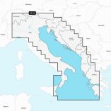
 Garmin Navionics Vision+ Nveu014r - Italy, Adriatic Sea - Marine ChartSpecial Price $205.55 Regular Price $249.99
 -
 Garmin Navionics+ Nseu014r - Italy, Adriatic Sea - Marine ChartSpecial Price $134.77 Regular Price $159.99
 -
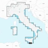 Garmin Navionics Vision+ Nveu073r - Italy, Lakes & Rivers - Marine ChartSpecial Price $205.55 Regular Price $249.99
 -
 Garmin Standard Mapping - Emerald Coast Professional Microsd/Sd CardSpecial Price $249.69 Regular Price $399.99
 -
 Garmin Standard Mapping - Florida West Pen Professional Microsd/Sd CardSpecial Price $249.69 Regular Price $399.99
 -
 Garmin Standard Mapping - Florida West Pen Premium Microsd/Sd CardSpecial Price $189.50 Regular Price $299.99
 -
 Garmin Navionics+ Nseu073r - Italy Lakes & Rivers - Marine ChartSpecial Price $134.77 Regular Price $159.99
 -
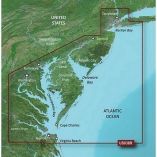 Garmin Bluechart G3 Vision Hd - Vus038r - New York - Chesapeake - Microsd/SdSpecial Price $278.58 Regular Price $349.99
 -
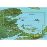 Garmin Bluechart G3 Vision Hd - Vca006r - P.E.I. To Chaleur Bay - Sd CardSpecial Price $292.18 Regular Price $349.99
 -
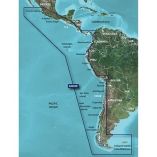 Garmin Bluechart G3 Vision Hd - Vsa002r - South America West Coast - Microsd/SdSpecial Price $278.58 Regular Price $349.99
 -
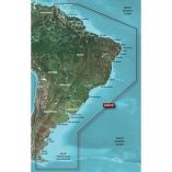 Garmin Bluechart G3 Vision Hd - Vsa001r - South America East Coast - Microsd/SdSpecial Price $267.74 Regular Price $349.99


