Search results for: 'INTERPHASE CHART MASTER 169CS CHARTPLOTTER p intu1 chrt 169'
- Did you mean
- interphase chart master 109vs chartplotter p insul chart 169
- interphase curt master 169cs chartplotter p intl curt 169
-
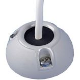
 Scanstrut Ds40-P Vertical Cable SealSpecial Price $38.42 Regular Price $50.99
 -

-
 Scanstrut Ds21b-P Vertical Cable SealSpecial Price $33.22 Regular Price $41.99
 -
 Scanstrut Ds21a-P Vertical Cable SealSpecial Price $35.35 Regular Price $41.99
 -

-
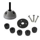 Scanstrut Ds6-P Vertical Cable SealSpecial Price $22.82 Regular Price $23.99
 -
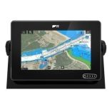 Raymarine Axiom+ 7 - 7" Mfd Chartplotter W/Lighthouse North America ChartSpecial Price $814.26 Regular Price $979.99
 -
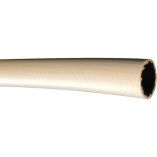 Trident Marine" X 50' Box Polyester Reinforced Air Conditioning HoseSpecial Price $73.34 Regular Price $110.04
 -
 Scanstrut Ds6-P-Blk Vertical Cable Seal - BlackSpecial Price $22.47 Regular Price $23.99


