Search results for: 'MAGELLAN BLUENAV XL3 CHART XLG904X p mag980845 09'
- Did you mean
- magellan bluewat xl3 curt xlg904x p mag980845 09
- magellan bluewat xl chart xlg904x p mag980845 09
-
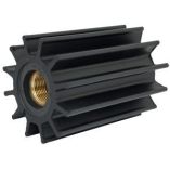 Johnson Pump 09-820b F95 Impeller (Neoprene)Special Price $259.61 Regular Price $494.15
 -
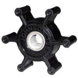
 Johnson Pump 09-1028bt-1 F7b Impeller (Mc97)Special Price $40.15 Regular Price $61.53
 -
 Johnson Pump 09-701b-1 Impeller (Mc97)Special Price $33.69 Regular Price $48.12
 -
 Johnson Pump 09-1052s-9 F3 Impeller (Nitrile)Special Price $30.44 Regular Price $41.81
 -
 Johnson Pump F5 Original Impeller Kit 09-1027b-1Special Price $37.83 Regular Price $56.18
 -
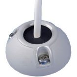
 Scanstrut Ds40-P Vertical Cable SealSpecial Price $38.42 Regular Price $50.99
 -

-
 Scanstrut Ds21b-P Vertical Cable SealSpecial Price $33.22 Regular Price $41.99
 -
 Scanstrut Ds21a-P Vertical Cable SealSpecial Price $35.35 Regular Price $41.99
 -


