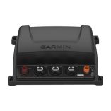
Search results for: 'Garmin Gpsmap8530 Black Box Plotter p gar010 01019 02'
- Did you mean
- garmin gpsmap8530 black box plotter p gar010 00012 02
- garmin gpsmap8530 black box plotter p ga200 0909 02
-
 Garmin 010-12000-02 Dvi-D 10 Meter CableSpecial Price $77.14 Regular Price $79.99
 -
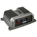
 Garmin Gcv 20 Ultra Hd Scanning Sonar Black Box - OPEN BOXSpecial Price $299.99 Regular Price $399.99
 -
 Garmin Gcv 20 Ultra Hd Scanning Sonar Black BoxSpecial Price $326.03 Regular Price $419.99
 -
-
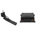 Garmin Gcv 20 Ultra Hd Scanning Sonar Black Box W/Gt34uhd-Tm Ultra Hd Transom Mount TransducerSpecial Price $484.58 Regular Price $629.99
 -
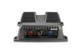 Garmin Gsd24 Sounder Box **Remanufactured**Special Price $517.20 Regular Price $599.99


