Garmin Navionics Vision+ Nveu620l Greenland & Iceland
Condition: New
Free Ground Shipping*
Garmin Navionics Vision+ Nveu620l Greenland & Iceland
Navionics Vision+™ NVEU620L Greenland & Iceland
Get the world’s No. 1 choice in marine mapping with the best, most up-to-date Navionics®+ cartography on your compatible chartplotter.
Featuring vibrant colors, a streamlined interface, and combined coastal/inland content with a popular Navionics® style color palette, Garmin Navionics+ cartography makes it easy to plot your course. Multiple shading options aid in shallow-water navigation and make it easy to highlight a target depth range for the best fishing spots. Fully customizable with various chart layers, overlay combinations, and up to 10 color-shaded target depth ranges, users can scope out the best fishing spots.
When you purchase a new Garmin Navionics+ or Garmin Navionics Vision+ cartography product, a one-year subscription is included.
Chart Code - NVEU620L
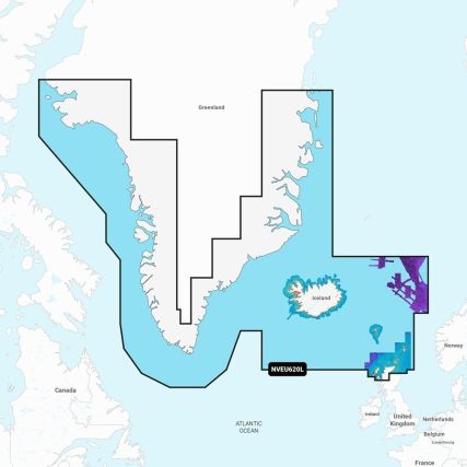
Coverage Area:
Detailed coverage of Greenland, Iceland, the Faeroe Islands, the Shetland Islands, the Orkney Islands, and the northern tip of Britain. Coverage includes Godhavn (Qeqertarsuaq) and Godthab (Nuuk), Greenland; Reykjavik and Akureyri, Iceland; Torshavn, Lerwick, Stromness, Kirkwall, and Thurso, United Kingdom.
Features:
- All-in-one Map Solution - Access detail-rich mapping of coastal features, lakes, rivers, and more. Integrated Garmin and Navionics® content offers coverage for boaters worldwide.
- Daily Chart Updates - Charts are constantly being enhanced with new and amended content — as many as 5,000 updates are made daily. The one-year included subscription gives you access to daily chart updates via the ActiveCaptain app.
- Auto Guidance+ Technology - Combining the best of Garmin and Navionics automatic routing features, built-in Auto Guidance+ technology1 gives you a suggested dock-to-dock path to follow through channels, inlets, marina entrances, and more.
- Depth Range Shading - High-resolution depth range shading lets you select up to 10 color-shaded options and view your designated target depths at a glance.
- Up to 1' Contours - For improved fishing and navigation, up to 1' contours provide a clear depiction of bottom structure for improved fishing charts and enhanced detail in swamps, canals, harbors, marinas, and more.
- Shallow Water Shading - To give a clear picture of shallow waters to avoid, this feature allows for shading at a user-defined depth.
- ActiveCaptain Community - Community-sourced content provides useful POIs, such as marinas, anchorages, hazards, businesses, and more. Get recommendations from boaters with firsthand experience of the local environment.
- High-Resolution Relief Shading - This downloadable shading feature combines color and shadow to give you an easy-to-interpret, clearer view of the bottom structure than contour lines alone.
- High-Resolution Satellite Imagery - Downloadable high-resolution satellite imagery provides superior situational awareness.
- Aerial Photography - Crystal-clear aerial and surface photos of ports, marinas, bridges, docks, boat ramps, dams, and navigational landmarks provide a better sense of your surroundings above the waterline.
- 3D Fisheye View - This underwater perspective shows a 3D representation of the bottom and contours from below the waterline. Interface with sonar data for a customized view.
- 3D Marinereye View - This view provides a 3D representation of the surrounding area above and below the waterline.
- Dynamic Lake Level - Adjust your maps to the lake’s current water levels to see if spots are accessible or too shallow to explore.
Compatibility:
- Check the compatibility of Garmin Navionics+ content and features with your GPS chartplotter
Technical Specifications:
- Format - MicroSD/SD Card
In the Box:
- SD/MSD Card
1Auto Guidance+ is for planning purposes only and does not replace safe navigation operations
2Raster cartography cannot be viewed on echoMAP™ CHIRP and ECHOMAP™ Plus combos but can be viewed on mobile devices via the ActiveCaptain mobile app
*Sold as an Individual
Manufacturer Part Number: 010-C1270-00
| Special Shipping Message | Free Ground Shipping* |
|---|---|
| Manufacturer Part Number: | 010-C1270-00 |
| Product Video: |
Return Policy
Hodges Marine accepts returns for up to thirty (30) days after shipment. Our return policy does not apply to the following goods: Open software, mapping/chart data cards, international orders, freight truck only items, and special order items. These items are not eligible for return, refund or exchange. Shipping charges (if any) are non-refundable. If your return is accepted by Us, We will provide one of the following within a reasonable time: an exchange of merchandise for the item returned, a non-transferable merchandise credit, a credit to the payment card or original method of payment used to pay for the item, a check, or another remedy that we determine in good faith is appropriate in the circumstances. Customer must request a return merchandise authorization (RMA) through the product returns link on our website or by emailing us at [email protected]. A RMA number will be issued with instructions for returning the package within a reasonable time (normally 1-3 business days).
Login and Registration Form