Navionics Platinum+ Npus011r - Canada North
Condition: New
Free Ground Shipping*
Navionics Platinum+ Npus011r - Canada North
Platinum+ NPUS011R - Canada North
Get the world’s No. 1 choice in marine mapping - with the best, most up-to-date Navionics+ cartography on a compatible chartplotter.
For offshore or inland waters, this all-in-one solution offers detail-rich integrated mapping of coastal waters, lakes, rivers, and more. Get SonarChart™ 1’ (0.5 meters) HD bathymetry maps and advanced features such as dock-to-dock route guidance technology, live mapping, and Plotter Sync to provide wireless access to daily updates.
The Navionics Chart Installer software also ensures the freshest chart data every time. Navionics dock-to-dock route guidance solutions suggest a path to follow through channels, inlets, marina entrances, and more. Multiple shading options aid in shallow-water navigation and make it easy to highlight a target depth range for the best fishing spots.
Navionics Platinum+™ charts include all the content of Navionics®+ cartography, with integrated offshore and inland mapping, 42,000+ lakes and additional viewing options for relief shading, satellite imagery with SonarChart shading overlay, 3D perspective view, aerial photos, and more.
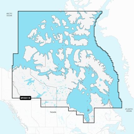
Chart Code: NPUS011R
Coverage Area:
Coverage of northern, coastal, and inland Canada, including the Northwest Territories, Nunavut, and northern Quebec. Includes major bodies of water such as Hudson Bay, Hudson Strait, Northwestern Passage, and inland lakes.
Features:
- Coastal Content - Offers detail-rich integrated mapping of coastal waters, lakes, rivers, and more
- Inland Content - 44,000+ lakes
- Detailed Nautical Charts - Comprehensive charts are derived from multiple officials, government, and private sources, displayed in a familiar look and feel
- SonarChart HD Bathymetry - Innovative 1' (0.5 m) bathymetry charts are created by using Navionics proprietary systems that augment existing content with sonar data contributed by the boating community
- Daily Updates - Up to 5,000 daily updates to the charts give the most accurate, most current Navionics data available
- Dock-to-dock Route Guidance2 - Start the trip with a suggested path
- Plotter Sync1 - Allows compatible chartplotter owners to transfer routes and markers, update chart layers, and more
- Community Edits - Get useful local knowledge from edits made by users of the Navionics Boating app on a compatible smart device
- Advanced Map Options1 - Customize the view to focus on the details that matter most
- SonarChartTM Live Mapping3 - Watch new 1' personal HD bathymetry maps develop in real-time as the boat moves along the water (it appears as an additional layer over the map, while it also gets stored on the device for future use)
- High-Resolution Relief Shading1 - Get an easy-to-interpret, clearer view of the bottom structure
- Satellite Imagery with SonarChart Shading Overlay - Experience an enhanced awareness above and below the waterline
- Sonar Imagery1 - View bottom hardness clearly and in a contrasting color
- Aerial Photos - Get a better sense of your surroundings
- 3D View - Adjust the perspective of your chart view to highlight key features and enhance awareness
Compatibility:
- Check the compatibility of Platinum+ content and features with a GPS chartplotter
Technical Specifications:
- Format: SD/MSD Card
In the Box:
- SD/MSD Card
1Subscription not required for the SonarChart Live mapping feature on some chartplotter models; requires the latest chartplotter firmware release.
2Dock-to-dock Route Guidance is for planning purposes only and does not replace safe navigation operations.
*Sold as an Individual
Manufacturer Part Number: 010-C1462-40
| Special Shipping Message | Free Ground Shipping* |
|---|---|
| Manufacturer Part Number: | 010-C1462-40 |
| Product Video: |
Return Policy
Hodges Marine accepts returns for up to thirty (30) days after shipment. Our return policy does not apply to the following goods: Open software, mapping/chart data cards, international orders, freight truck only items, and special order items. These items are not eligible for return, refund or exchange. Shipping charges (if any) are non-refundable. If your return is accepted by Us, We will provide one of the following within a reasonable time: an exchange of merchandise for the item returned, a non-transferable merchandise credit, a credit to the payment card or original method of payment used to pay for the item, a check, or another remedy that we determine in good faith is appropriate in the circumstances. Customer must request a return merchandise authorization (RMA) through the product returns link on our website or by emailing us at [email protected]. A RMA number will be issued with instructions for returning the package within a reasonable time (normally 1-3 business days).
Login and Registration Form